- Login
Sajek Valley , Bangladesh
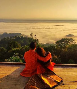
🏞️ Sajek Valley – The Queen of Hills and Clouds Best Time to Visit: September to March
Ideal For: Nature lovers, couples, photographers, adventure seekers
📍 Overview
Nestled in the Chittagong Hill Tracts between Rangamati and Khagrachari, Sajek Valley is famous for its cloud-kissed hills, lush greenery, and panoramic views. Located about 1,800 feet above sea level, Sajek offers breathtaking sunrises, starry nights, and a unique cultural experience with indigenous communities.
It’s often called the "Roof of Rangamati", though it’s more accessible from Khagrachari.
🌄 Top Attractions & Viewpoints
| Spot | Highlights |
|---|---|
| Konglak Hill | Highest peak in Sajek, amazing sunrise and cloud views |
| Helipad Area | Central viewpoint, perfect for morning and sunset photos |
| Risa Para & Konglak Para | Indigenous villages showcasing tribal life and crafts |
| Stone Garden | Natural rock formations and scenic walks |
🏕️ What to Do in Sajek
-
🌤️ Watch the sunrise above the clouds
-
🥾 Trek to Konglak Hill
-
📸 Capture the cloud-invaded mountain views
-
🏘️ Interact with indigenous communities (Lushai, Chakma, Tripuri)
-
🔥 Enjoy a tribal cultural night with BBQ
-
🌌 Stargaze in the clear night skies
🏨 Where to Stay
Sajek offers a range of hillside cottages and resorts with balcony views:
-
Luxury: Meghpunji Resort, Sajek Resort
-
Mid-range: Jumghor, Megh Machang, Ruilui Hill View
-
Budget: Indigenous homestays (simple but scenic)
🔔 Tip: Book well in advance, especially on weekends and holidays.
🍴 What to Eat
-
Tribal-style chicken BBQ
-
Bamboo-cooked rice and local vegetables
-
Fresh pineapples and seasonal fruits
-
Tea at mountain cafes with epic views
🚐 How to Get There
-
From Dhaka:
-
Overnight bus to Dighinala or Khagrachari (8–9 hrs)
-
Reserve a Chander Gari (4x4 Jeep) from Khagrachari to Sajek (2–3 hrs)
-
-
Travel Permits:
-
Foreigners need permission from the DC Office in Khagrachari
-
Carry NID/passport for checkpoints
-
📋 Travel Tips
-
Carry cash—no ATMs in Sajek
-
Mobile network is limited (Grameenphone works best)
-
Warm clothes are essential, especially at night
-
Respect local culture and dress modestly
-
Stay hydrated and wear trekking shoes if hiking
-
🌥️ Sajek Valley – The Cloud Kingdom of Bangladesh
📍 Geography & Climate
-
Location: Sajek is located in Baghaichari Upazila of Rangamati District, but is best accessed via Khagrachari.
-
Altitude: Approx. 1,800 feet above sea level
-
Climate: Cool and refreshing.
-
Winter (Nov–Feb): 10°C to 20°C
-
Monsoon (June–Sept): Cloud-covered and lush
-
Best months: Sept to March for clear views and cloud play
-
Sajek is part of the Lushai Hills range, with dense forests, bamboo groves, and breathtaking ridgelines.
🧭 Detailed Route Guide
From Dhaka to Sajek (estimated time: 10–13 hrs):
-
Dhaka → Khagrachari (Bus: 7–8 hrs)
-
Buses: Shyamoli, Soudia, Saintmartin Paribahan (AC & Non-AC options)
-
Depart at night to reach by early morning
-
-
Khagrachari → Dighinala → Sajek (2.5–3.5 hrs)
-
Chander Gari (local 4x4 jeeps) are mandatory due to steep terrain
-
Road includes security checkposts (especially for foreigners)
-
🛑 Permit Note: Foreign nationals must obtain permission from the Khagrachari DC Office with a photocopy of their passport or NID.
🏞️ Detailed Points of Interest
Location Description Helipad Ground Iconic open space for photos; popular for sunset and starry skies Konglak Hill The highest point in Sajek; requires a short uphill trek (~30–40 minutes) Risa/Konglak Para Lushai tribal villages—colorful homes, warm locals, traditional weaving Stone Garden Recently developed; scenic rocky landscape, ideal for photography Ruilui Para Waterfall A small seasonal waterfall near the cottages area 📌 Pro Tip: Visit Konglak Hill early in the morning for a jaw-dropping sea-of-clouds view!
🏨 Accommodation Guide
💼 Premium Resorts:
-
Meghpunji Resort – Famous for its infinity view balconies
-
Sajek Resort – Government-run, well maintained
-
Megh Machang – Built with local materials; cozy and scenic
🏠 Mid-range & Local:
-
Runmoy Resort – Affordable and clean
-
Jumghor Cottage – Run by locals, close to main viewpoints
-
Indigenous Homestays – Best for cultural immersion (basic facilities)
❗ Electricity is solar-powered in most cottages. Prepare for occasional outages.
🍲 Food & Dining
-
Local tribal meals: Sticky bamboo rice, chicken BBQ, banana flower curry, bamboo shoot dishes
-
Pineapple, papaya, and other local fruits are fresh and delicious
-
Food must often be pre-ordered in the cottage you're staying in
-
Tea stalls and small cafés available near Ruilui Para
🧑🤝🧑 Culture & People
Sajek is home to several indigenous communities, notably:
-
Lushai (majority)
-
Chakma
-
Tripuri
They speak Lushai and Chakma, but many also understand Bengali. They’re known for their:
-
Colorful traditional attire
-
Handwoven fabrics and crafts
-
Warm hospitality and simple living
🧣 You can buy handwoven shawls, bags, and bamboo crafts from the local markets.
🔒 Safety & Essentials
-
Sajek is very safe for tourists; there's a strong presence of army camps ensuring security.
-
There are multiple checkpoints, so carry ID at all times.
-
Limited mobile network; Grameenphone works best.
-
There are no ATMs, so bring sufficient cash.
🎒 What to Pack
Essentials Why? Light warm clothing Chilly mornings and nights Hiking shoes Needed for Konglak Hill and village walks Power bank Electricity may go out Sunscreen & sunglasses Bright sunlight at altitude Flashlight Night walks are common Dry snacks & water Food may take time in remote areas
🎉 Special Experiences to Try
-
Campfire with local music and BBQ
-
Cloud bath – literally walk through clouds in early morning
-
Photography – drones, telephoto lenses, and long-exposures for night skies
-
Trekking to remote para (villages) guided by locals
-
Stargazing – due to almost no light pollution
-
🧭 Quick Facts
| Feature | Details |
|---|---|
| Elevation | ~1,800 feet |
| Nearest Town | Khagrachari (~70 km away) |
| Indigenous Groups | Lushai, Tripuri, Chakma |
| Internet Connectivity | Very limited (a blessing for some!) |